A Double Take on the Northern Lights
A method using consumer grade photography gear offers a fresh look at the aurora borealis.

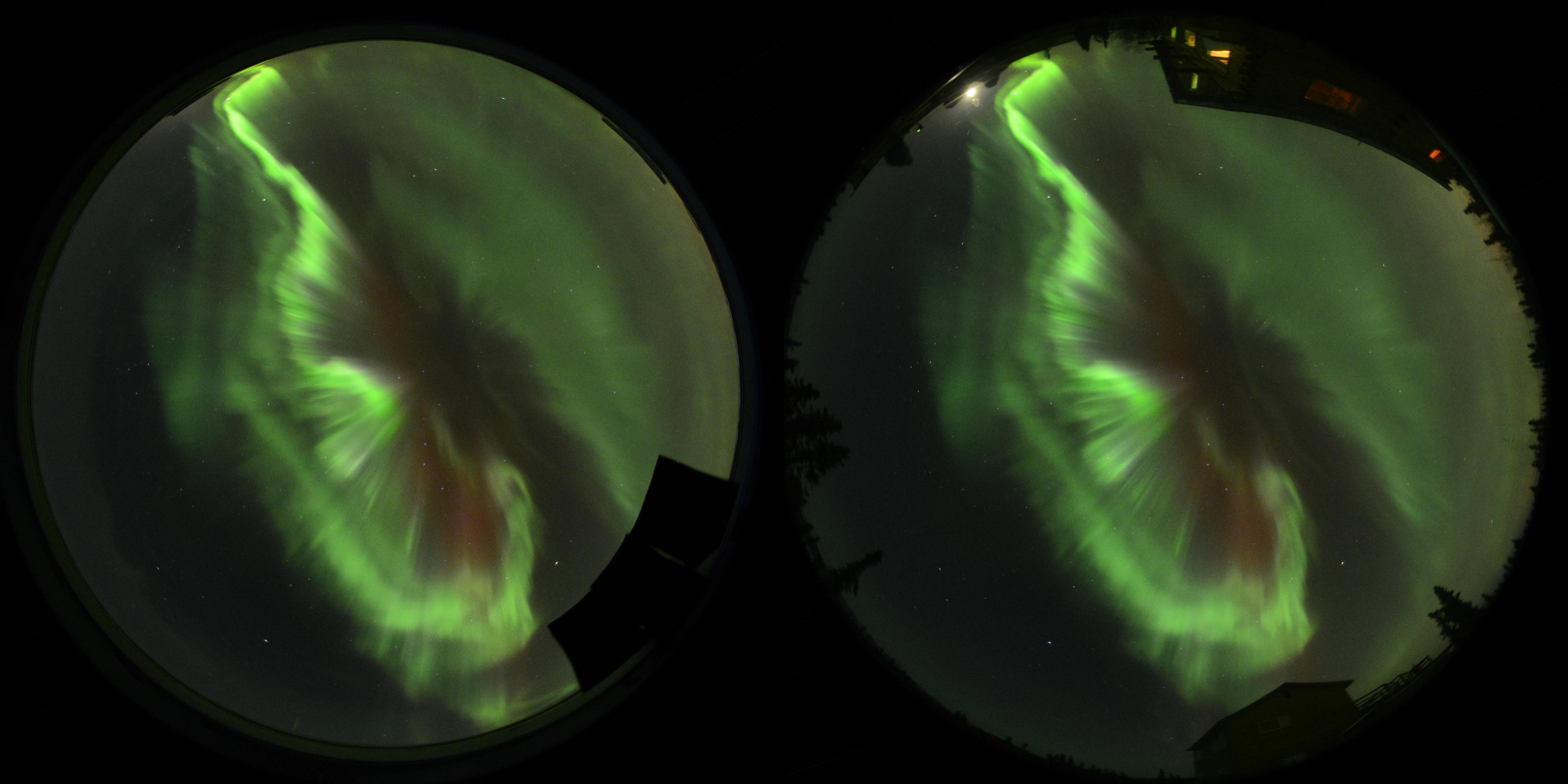
A "left eye" and "right eye" view of the northern lights. Credit: Kataoka et al., 2013
Auroras, like ethereal flags fluttering in the solar wind, dazzle and intrigue those of us fortunate to catch a glimpse. Ryuho Kataoka, an associate professor at the National Institute of Polar Research in Tokyo, is lucky enough to study the phenomenon for a living. One question drives his research: “What is the connection between space and the earth?’” he asks. “The aurora is a visualization of that connection.”
The luminescent glow typical of auroras comes from light that’s emitted when high-energy particles that have been ejected from the sun and waylaid by earth’s magnetosphere collide with atoms and molecules in our upper atmosphere (for a detailed explanation, here’s a video from TED). Using only consumer-grade photography equipment and a GPS system, Kataoka and an international team of scientists devised a way to gather valuable information about the altitudes of these dancing lights.
The technique, published in the journal Annales Geophysicae this past September, improves upon a century-old method. In the early 1900s, Norwegian scientist Carl Stormer and an assistant donned fur coats and braved freezing Arctic temperatures in order to take simultaneous photographs of auroral features from different locations in Norway. By comparing pairs of pictures, Stormer could triangulate the height of portions of the aurora—the first scientifically credible attempt to do so, says Sten Odenwald, a space scientist at NASA. (To envision how the method works, extend a finger at arm’s length in front of your face, and look at it alternately with just the left eye, then the right. The finger moves, yes? That’s called a parallax shift. Stormer’s picture pairs offered a “left eye” and a “right eye” view, allowing for calculation of an angle that could be used to pinpoint actual auroral height. For more on parallax, check out this NASA explainer). Stormer’s team found that the lights extended from about 22 to nearly 300 miles above the earth.
The technology that Kataoka and his colleagues used provides more precise measurements. They set up digital Nikon cameras—equipped with wide-angle fisheye lenses capable of capturing expanses of sky—about five miles apart in Alaska. GPS attachments allowed them to determine the exact distance between each location, where they snapped simultaneous pictures and took videos of the aurora borealis. Using parallax, the team was able to calculate height measurements of ribbons and other auroral features, marking the first time the northern lights’ altitude has been measured using digital SLR cameras. The heights—higher than 62 miles for some auroral features and lower for others—jibed with previous calculations by other researchers.
Calculating the height of auroras can help scientists figure out the energies of their particulate makeup—information that can in turn offer clues to better understanding the earth’s magnetic field. Indeed, the magnetic forces around our planet shield us from solar wind, which rips through space with enough energy to obliterate life, according to Joshua Semeter, a professor at Boston University who studies space weather. The aurora phenomenon “gives us a flashlight to peer into the magnetic field around our planet that would otherwise be invisible.”
For his part, Kataoka envisions a network of citizen scientists snapping pictures of auroras and submitting them to a database accessible to researchers, who could then use them to learn even more about one of the world’s most stunning phenomenon.
Andrew is a New York-based freelance writer. He was Science Friday’s intern during fall 2013.