Return Of The GEDI: Scanning The Amazon With Lasers
Data collected by an instrument on the International Space Station gives scientists insight into deforestation in the Amazon rainforest.
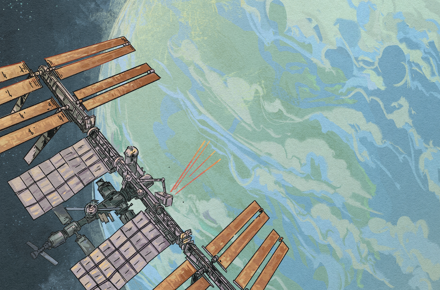
A full-waveform LIDAR system attached to the International Space Station provides high-resolution observations of forests' vertical structure for NASA's GEDI mission. Illustration by Jay Rasgorshek, for Science Friday.
This story was produced by Science Friday and América Futura as part of our “Astronomy: Made in Latin America” newsletter and series. It is available in Spanish here.
Orbiting 250 miles above Earth, the International Space Station is a lot like a neighborhood. Some people move in, others move out. And amid the chaos of moving—pending decisions, switching tenants, or changing experiments—sometimes it’s necessary to place highly valuable possessions in storage.
NASA has just extended the GEDI mission (pronounced Jedi, like the characters in “Star Wars”) which, after a year in hibernation, became operational at the end of April. Its powerful instrument shoots laser beams down from space to scan nearly all of the tropical and temperate rainforests on Earth, including the largest of all of them, the Amazon, which currently stores 17% of the world’s carbon stock.
Measurements taken from the forest scans allow researchers to form detailed, three-dimensional maps and calculate the amount of carbon those millions of trees store. This information is critical to determine the health of rainforests and, in turn, understand how much they are helping slow climate change by absorbing CO2. It’s also critical for the burgeoning carbon-offset markets. Reflecting this growing interest, the GEDI mission has just been extended until 2030.
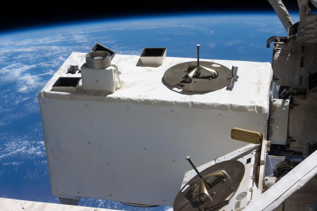
The GEDI mission (Global Ecosystem Dynamics Investigation) collects data on forest height, structure, and surface elevation, and uses it to generate ultra-high-resolution 3D images. The information is obtained by shooting three lasers from an arm of the International Space Station at lightning speed (242 shots per second). Each laser bounces off a spot of the forest that’s 82 feet in diameter.
“GEDI is the first laser technology specifically designed to penetrate tree canopies and show the horizontal and vertical structure of forests,” says Dr. Adrián Pascual Arranz, a Spanish forest engineer at the University of Maryland, which is leading the GEDI mission with NASA’s Goddard Space Flight Center.
Now that climate change is more evident than ever—as demonstrated by extreme weather events and record-breaking heat—interest in GEDI data has grown. Dr. Ralph Dubayah, lead researcher of the project at the University of Maryland, explained why in an email: “Estimates of forest structure and biomass from GEDI are critical to the success of global environmental policies, such as the Paris Agreement’s Global Stocktake (the degree to which countries are meeting goals set by climate agreements), MRV (measurement, reporting and verification of how much carbon countries are emitting and absorbing), and for the conservation of biodiversity on a global scale.”
Dubayah adds that thanks to the measurements, researchers and other GEDI users now have data from highly remote places such as the Amazon, Patagonia, and the Andes. Not long ago, such precise measurements would have been nearly impossible to obtain.
Dr. Matheus Nunes, a Brazilian tropical ecologist and GEDI researcher at the University of Maryland, emphasized that the measurements are so detailed that they can even detect the illegal logging of the most valuable wood, a more discreet crime that can be challenging to prosecute but is still damaging to forests. Information on how much carbon a forest stores is becoming particularly valuable in the face of growing carbon markets, which are trading systems that allow those who pollute excessively to compensate for it by paying those who preserve more. “Admit it or not, everyone is using our data in the carbon markets,” Nunes says.
The 25 billion measurements taken since the project was launched in 2018 are accessible to anyone for free, courtesy of US taxpayers. “The use of GEDI data by the scientific community and for operational applications has been incredible and has empowered organizations and researchers worldwide,” says the mission’s lead researcher.
How can they tell how much carbon a forest stores? Researchers analyze the light that bounces back after the laser passes through the forest canopy and tree leaves. This allows them to estimate the height and density of the forest in a given spot, and calculate the biomass and carbon of that area “using models previously calibrated between field measurements and GEDI observations,” explains Pascual. Thanks to these models, it’s now known that each ton of forest biomass is equivalent to 0.47 tons of stored carbon.
“By extending the mission, we will have almost ten years’ worth of data,” assures Pascual, who adds, “it also allows us to compare areas where measures have been taken to increase carbon through farming, forest management, fire prevention, and stopping illegal mining, with other areas where no such measures have been taken.”
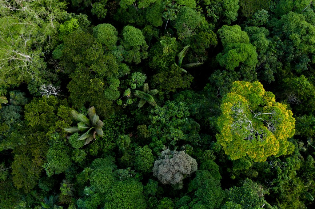
Starting a few years back, anyone who flies can see on their ticket the carbon footprint, or CO2 emissions, that a flight generates. But how does it compare to rainforests’ ability to store it? The amount of carbon stored in one hectare (2.5 acres) of Brazil’s healthiest forests—such as the sanctuary of giant trees in the state of Pará, where some specimens reach 262 feet tall—is equivalent to flying 5,000 travelers between São Paulo and Brasília on commercial airlines. By private jet, the figures soar.
The refrigerator-sized GEDI instrument shoots laser beams and scans the planet following the orbital path of the International Space Station, which repeats every three days. The result is a detailed map that shows how much carbon is stored in different rainforests and in different areas within the forests, because the areas are so huge that the amount of carbon they store varies greatly.
As the largest tropical forest on the planet, the Amazon covers 2 million square miles of Brazil and eight other countries (Bolivia, Colombia, Ecuador, Guyana, French Guiana, Peru, Venezuela y Suriname). It is a colossal landmass with varying degrees of carbon absorption capacity. There are biodiverse areas of rich vegetation that store a lot of carbon. Other areas are bare, without a single tree due to the increase in soybean farming, illegal logging, and mining. Where the health of the forest has deteriorated, so has its ability to absorb greenhouse gases. Over the past two decades, the planet has lost some 12,000 to 15,000 square miles of primary forest each year, according to Global Forest Watch.
GEDI scans can also measure the effect of natural events, such as fires or the impact of humans, on forest ecosystems. Pascual explains that his data is now used by the World Bank, the National Forest Inventory (NFI), in forest inventories, and by companies in the geospatial industry, such as Planet. He himself is frequently consulted. Recently, he was contacted by Amazon Conservation, an NGO that wants to include satellite data in its reports on the effect of deforestation and illegal mining in parts of Peru and Bolivia. The GEDI mission offers tutorials on how to process and use its data.
This story was translated from Spanish by Laura González.
Naiara Galarraga Gortázar is a correspondent for El País in São Paulo, Brazil.