Water, Water, Everywhere
5:08 minutes
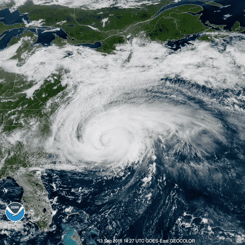
As Hurricane Florence approaches the Carolinas this week, forecasters and disaster management officials are stressing one key piece of advice to evacuating residents: Take the storm seriously, regardless of the category designation. Once projected to hit Category 4, Florence was at Category 2 as of Thursday morning, but that number only describes the wind speed. Meanwhile, as University of California-Irvine civil engineer Amir AghaKouchak notes, there could be unusually devastating flooding, as storm surge from the ocean meets rainfall from a storm that is projected to pour on the region for days.
“Compound flooding” is the phenomenon that left Houston under water after Hurricane Harvey in 2017, and, at its worse, could cause rivers to run in reverse. And, AghaKouchak says, climate change and sea level rise both make such flooding more likely in storms such as Florence.
AghaKouchak talks to Ira about flooding, Florence, and the factors that could shift the storm favorably or unfavorably in the coming days.
Amir AghaKouchak is an associate professor of civil engineering at the University of California-Irvine.
IRA FLATOW: After long anticipation, Hurricane Florence hit the Carolina coast and downgraded from a category four to a category one storm. It, nonetheless, comes with predictions of 90 mile per hour winds, potentially as many as 40 inches of rain in some places, and a storm surge that has already reached 10 feet above normal sea levels in some places, which is why more than a million people were urged to evacuate before the storm.
My next guest is here to talk about all that water. What happens when high seas meet unrelenting rain? Well, it’s a unique kind of flooding, he says, that we can expect to see more of as the globe warms and sea levels rise. Amir AghaKouchak is Associate Professor of Civil Engineering University of California at Irvine, and he joins us by Skype. Welcome to Science Friday.
AMIR AGHAKOUCHAK: Good to be with you.
IRA FLATOW: Nice to have you. Just looking at Hurricane Florence, we’re hearing already about having more than a foot of rain having fallen, the storm surge topping 10 feet in some places. What are the flooding dynamics at play right now?
AMIR AGHAKOUCHAK: Right. Hurricane Florence is a relatively slow-moving hurricane. Just to give you an idea, the average forward speed ranges from 10 to 35 miles per hour. But the average speed of Florence is being less than 10 miles per hour, I think around five miles per hour or so. So this means that there is higher chance of substantial rain over one specific city or basin. So this is one interesting and unique aspect of this hurricane.
IRA FLATOW: We’re hearing news, also, about really bad flooding in towns way inland. Like, there’s a town of New Bern in North Carolina. It’s not directly on the coast. I think it’s 20 miles upstream, so to speak, and it’s at the junction of two rivers. And the town’s getting squeezed in two directions.
AMIR AGHAKOUCHAK: Right. So obviously, with hurricanes comes surge and extreme rain, and both are drivers of the coastal flooding. When multiple drivers, like surge and rainfall, interact and cause flooding, they can be called a compound coastal flooding. And these events can go way inland, of course, depending on physiographic features.
So why is this important? The amount of water that the river can discharge into the ocean is a function of the gradient between river mouth and the ocean water level. So the higher the ocean water level, the less water can drain into the ocean. And in fact, the surge and high waters can cause the river to go backwards, backwards inland, and cause even more significant impact. So this is a kind of compound coastal flooding event.
IRA FLATOW: Right. We talked about how slowly this storm is moving. Is this partially true because of climate change, creating stronger storms, wetter storms, other ways a changing climate could alter the floods we see in hurricanes?
AMIR AGHAKOUCHAK: Right. So in the past couple of decades, rainfall associated with tropical cyclones and hurricanes have increased. And many studies have linked to the observed increase in rainfall to the increasing sea surface temperatures due to anthropogenic climate change.
Sea surface temperatures can impact the size and intensity of storms because hurricanes and tropical cyclones gain their heat, moisture, and also energy from the surrounding sea surface temperatures. So our satellite observations and direct measurements already show that sea surface temperatures have been warming in most oceans around the world.
IRA FLATOW: Can we expect this kind of compound flooding to be commonplace in future storms or even during regular high tides as global climate change kicks in?
AMIR AGHAKOUCHAK: Absolutely. The problem we have is that sea levels have been rising and they are projected to rise in the future. This means that baseline ocean water will be higher in the future. So it means in future hurricanes and the surge that will be added to a higher baseline– and obviously higher water level– can cause more impacts, more coastal flooding impacts.
IRA FLATOW: What kind of infrastructure, then, do we need to cope with this?
AMIR AGHAKOUCHAK: Well, this question is very local. So in some areas, sea levels are projected to rise more and someplace it’s less. So there is no single solution for everywhere. This requires a lot of investigations and studies modeling, understanding our exposure and how future is going to change. But the kind of strategies include relocation to building seawalls and levees and things like that.
IRA FLATOW: Thank you very much for taking time to be with us today, Amir.
AMIR AGHAKOUCHAK: Absolutely.
IRA FLATOW: Amir AghaKouchak is Associate Professor of Civil Engineering at the University of California-Irvine.
Copyright © 2018 Science Friday Initiative. All rights reserved. Science Friday transcripts are produced on a tight deadline by 3Play Media. Fidelity to the original aired/published audio or video file might vary, and text might be updated or amended in the future. For the authoritative record of Science Friday’s programming, please visit the original aired/published recording. For terms of use and more information, visit our policies pages at http://www.sciencefriday.com/about/policies/
Christie Taylor was a producer for Science Friday. Her days involved diligent research, too many phone calls for an introvert, and asking scientists if they have any audio of that narwhal heartbeat.